Issued: 03/08/2002
Updated As Warranted
See ENSO page for Links and Current Data
ENSO Archives
STRONGER SIGNALS FROM
EL NINO DEVELOP
Next 2 Months Are Key
Since May 2001 we have been watching the Tropical Pacific Ocean change from being dominated by La Nina to a more El Nino like configuration. That trend continued to strengthen in fits and starts over the past 3 months. Some data now suggests a mild to moderate El Nino might develop by July 2002.
Seasonally adjusted Sea Surface Temperatures (SST) across the equatorial Pacific Ocean since August 2001 have consistently indicated that a warm-up is in progress. It is mainly attributable to eastward propagating Kelvin waves. During La Nina years, warm water pools up in the extreme western equatorial Pacific, driven there by abnormally strong trade winds (blowing east to west along the equator). And cooler than normal SST's normally occupy the eastern tropical Pacific (off Columbia, Ecuadir and Peru), driven by the same winds creating deep-water upwelling. In May 2001, a sudden reversal of the wind pattern took.cgiace, with trade winds in the West Pacific starting to turning calm, and even occasionally blowing towards the east along the equator. One particularly strong burst of easterly winds pushed a large surge of warmer water (known as a Kelvin wave) towards South America. That wave reached the South American coast in late July. Since then several others have followed, with the most recent one arriving this month (March). Kelvin waves often signal the start of an El Nino cycle, but not always. Eastward propagating Kelvin waves are driven by the Madden-Julian Oscillation (MJO), a cyclical weather pattern with duration of 30-60 days per cycle. The MJO is characterized by a weak low pressure center that develops in the east Indian Ocean and tracks eastward along the equator, against the normal flow of tropical systems. With it comes easterly wind which in-turn interact with the oceans surface and push the warm water present there eatward as well, thus potentially producing Kelvin waves. Kelvin waves are a pool of warmer than normal water that travel east under the oceans surface at a depth averaging about 150 meters. They can be evidenced at the surface by a slight rise in sea surface height (8 cm) and slight temperature increase. They are tracked primarily using an array of 70 buoys anchored along the entire width of equatorial Pacific, from Papua New Guinea to just off the Ecuador coast. Temperature sensors located a various depths along the buoys anchor-line record any change in sub-surface water temperature. The sensors relayed their data real-time via satellite to a central processing facility. MJO pulses can migrate as far east as the dateline. The MJO reaches it's peak during the transition from winter-to-summer and summer-to-winter. This pattern could prove key to driving additional warm equatorial surface water eastward.
As of this report, average sea surface temperatures from the far western equatorial Pacific eastward to the Marquesas Islands (about 65% of the way across the Pacific at 140W) were about one half a degree (C) above normal. A pool of still warmer water (at 1 degree C) was building off the South American coast. This is significant because though the mid and western Pacific have been warmer than normal for some time, this warmth has failed to materialize off South America with any intensity until March 2002, in-sync with the arrival of the latest Kelvin wave. There is also evidence that warmer water is propagating northward along the immediate coast of Central America and Mexico and south towards Chile.
Average trade wind velocity along the equator in the West Pacific still remains calm and are even blowing towards the east as has been the case since early October 2001. This again is in sharp contrast the pattern over the previous 3 years. Sea surface height, that is, the height of the seas surface relative to 'average' is slightly above normal as well, covering a thin band almost the entire way across the equatorial Pacific, ranging from 6 cm in the west to near 15 cm off South America. Water that is higher than normal is also typically warmer than normal, so this measure further confirms the temperature pattern indicated above. The latest data indicates the pattern is stronger than even 3 months ago.
Looking at the larger scale global picture, waters of the southern hemisphere are generally warmer than normal, while the north hemisphere is cooler than normal. The Pacific warm water horseshoe pattern that has been in.cgiace for the past 3 years, the trademark of the latest La Nina pattern, is still present. The horseshoe is evidenced by a large pool of warmer than normal water extending from North Japan northeastward to just north of Hawaii and southeast from North Australia to nearly Chile. Much cooler than normal water continues to plague the Aleutian storm corridor and the Gulf of Alaska, extending down to the Pacific northwest states. This horseshoe pattern appears to be having no affect on the developing warm waters in Eastern Pacific though.
The Southern Oscillation Index (SOI), which compares relative barometric surface pressure between Darwin, Australia and Tahiti has continued to see-saw between positive and negative. On the whole, it has not yielded evidence to suggest either El Nino or La Nina, but rather tends towards a neutral pattern. A positive SOI indicates La Nina while a negative SOI indicates El Nino. It started indicating daily negative anomalies in mid-April 2001 and continued on that trend through May, and strongly so at times. The SOI index for the month of May averaged -9.9. This was the first time since the onset of La Nina in late '98 that any extended period of negative anomalies had been measured. A negative anomaly indicates that lower than normal average pressure is present over the Central Pacific while higher than normal pressure is in the far West Pacific. The negative SOI pattern retreated somewhat during June ('02), with the average SOI up to +2.4. Then in July the trend returned negative, at -3.3 and -8.3 in August. September retreated somewhat to 1.7, but October again turned negative at -3.0. November was up to 9.0 and December rounded out the year at -11.2. January and February of 2002 has been 2.5 and 7.1 respectively. One would want to see a continued negative SOI to say that an El Nino is in-progress. But NOAA reports that the SOI is not necessarily a good early-lead indicator. Rather, it turns negative only after a warm SST pattern has been in.cgiace long enough and with enough intensity to start modifying the atmospheric patterns above it.
Another key indicator in the evolution of either an El Nino or La Nina event is the depth and profile of the 20 degree thermocline. During La Nina events, warm sub-surface water remains pooled up in the far West Pacific near the equator, with cold surface and subsurface waters dominating the East Pacific, resulting in a steep angle from east to west, going from shallow in the east to deep in the west. In El Nino events, as warm subsurface water (i.e. Kelvin waves) migrate towards the eastern Pacific, the angle flattens and becomes more consistent across the equatorial Pacific. The latest data indicates one Kelvin wave is hitting the South America coast with subsurface temperatures at 4 degrees C above normal. Yet a second one 2 degrees C above normal is positioned 125 meters below the dateline, tracking east. This strongly points toward El Nino.
Outgoing Longwave Radiation (OLR) anomaly data (which measures cloud reflectivity/cloud cover) and rainfall measurements indicate a net increase in precipitation along the equator from Papua New Guinea to the dateline and just off the coast of South America on the equator. NOAA indicates that this might be the first clear signs of El Nino starting to manifest itself in the atmosphere.
Of 11 ENSO models run in February 2002, 4 are indicating warm conditions by July 2002, with 2 more indicating warm conditions by October. Sea-surface and sub-surface temperature forecasts from NOAA/NCEP indicate generally neutral conditions through June, with significant warming of the tropical East Pacific building into a full scale El Nino by July 2002. Seeing that the warm sub-surface migration is already in progress, that atmospheric precipitation near the dateline is enhanced, and that surface winds remain light in the West Pacific, it seems probable that many of the forecast models are out-of-sync with the weak El Nino that appears to already be occurring. NOAA might be capturing the current trend best. But a note of caution: It is difficult to predict beyond the seasonal change known as the Spring Barrier (March and April). Though an El Nino pattern appears to be establishing itself, such trends have been known to change suddenly and reverse direction during the barrier. By early May the forecast for the rest of the year should become much more stable. Monitor this situation closely.
LONG RANGE NORTH PACIFIC STORM AND SWELL DEVELOPMENT FORECAST
Spring/Summer 2002 Swell Potential Rating (for California) = 6.5
Forecasts data for the spring and summer of 2002 indicate that normal to slightly above normal water temperatures are expected for the equatorial Pacific, indicative of developing El Nino conditions. The continued presence of horseshoe warm-water pattern in the North and South Pacific will likely remain in.cgiace as it has for several years, but with diminished strength. It will likely have no impact on storm generation potential in either the North or South Pacific. It is unknown whether anomalously high pressure will again set-up east off Australia and negatively impact the winter storm pattern there. But the potentially building presence of El Nino should serve to a.cgiify the development of tropical systems off Central America throughout the season and re-direct late season typhoons off North Japan towards the open waters south of the Aleutians, enhancing the probability for extra-tropical storm development. Some of this started to occur in the fall of 2001, and we expect to see a stronger trend by late summer 2002.
(This forecast is highly speculative and based on historical analysis of past La Nina/El Nino events and the latest long-range forecast models)
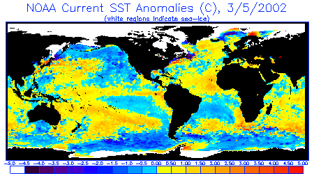
Sea Surface Temperature Anomalies
Courtesy: NOAA NESDIS
Notice a distinct current of warm water that now extends from New Guinea eastward to
Ecuador, then branching south along the Peruvian coast into Chile and northward to Baja
Mexico. The warm water horseshoe pattern is also still present, extending east from
Japan and southeast of Australia. Cooler waters remain along the Aleutians and Gulf
of Alaska south through the Pacific Northwest.
 |
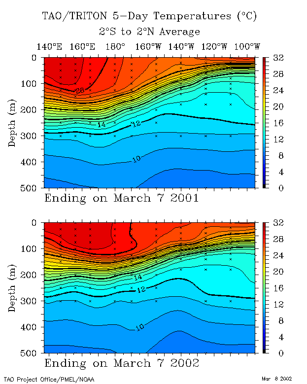
20 Degree Thermocline Depth and
Position Time Series
Courtesy: CPC NCEP NOAA
Over the past year the core of warm sub-surface water that dominated the western Pacific
has made serious inroads to the east and is increasing it's depth there as well.
 |
Sea Surface Temperature Anomalies
and Average Surface Winds on the Equatorial Pacific
Courtesy: NOAA PMEL
Notice warmer than normal SST conditions currently (+0.5 degrees C) cover almost the
entire equatorial Pacific. A core a warm water to 1.0 C is building along the south
American coast too. Also notice anomolously neutral winds over pockets of the
equator and that the trades have died in the far West Pacific.
 |
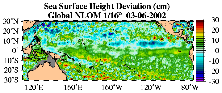
Sea Surface Height Deviation
Courtesy: NLOM
Notice that seas heights are higher than normal almost continuously along the equator and
much more so off Ecuador, indicating warmer than normal water at the surface and
below.
 |
Equatorial Pacific Sea Surface
Temperature Forecast
Courtesy: NOAA/NCEP
Notice that 4 separate models runs (using different starting dates) indicate water
temperatures over the Central Pacific are to remain warm but steady through May, then
start heating up by July.
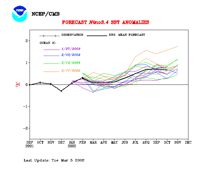 |
Equatorial Pacific Sea Surface Temp
Forecast
Courtesy: NCEP/CMB
Notice Sea Surface Temps are to remain generally neutral through June 2002, then go
strongly warm along the equator from through the end of the year.
 |
6399
|
||||||||
|
||||||||
