Neutral Conditions Officially
But MJO and Kelvin Wave Activity Continues
Signals of a weak El Nino persist, though not so strong as to be significant. The continued persistence of these 'under the radar' signals over the past year are taking their toll on the atmosphere, slowly and steadily building momentum. Starting with the winter of 2003/2004 a generally neutral trend was in.cgiace with occasional signals of a developing El Nino. That trend continued through 2004 with the strength and frequency of the El Nino-like periods increasing, enough to pass over the threshold to be considered a minimal but official El Nino by late August. By early 2005, things looked to be settling back down, but then as forecast, a major eruption of the Madden Julian Oscillation (MJO) occurred the first week of February, spawning a 40 day run of a very negative Southern Oscillation Index, the strongest for that time of year since the big El Nino of 97/98. A significant increase in Northern Hemisphere storm activity ensued producing a string of significant class swells and producing a strong eastward moving Kelvin Wave. As the MJO and SOI settled back down, the winter storm season faded. But in mid-April another negative run of the SOI supported by a renewed active phase of the MJO started, and the Northern Hemisphere storm track tried to respond. At this time it appears the upper level circulatory changes typically associated with El Nino are in.cgiace, with a direct link now established between the MJO and the North Pacific storm pattern, something that was not present 6 months earlier. We are currently in the Spring time 'Predictability Barrier', so any particular forecast is uncertain, but the pieces are slowly and steadily falling into.cgiace, which is the best scenario for long term storm (and surf) development on west facing Northern Hemisphere shores.
Looking at current seasonally adjusted equatorial Pacific Sea Surface Temperatures (SST), the affects of the low level atmospheric changes are apparent. Consistently warmer than average water temperatures persist over the entire length of the equator, averaging 0.5-0.75° C with a pocket of much warmer water 1-2° C erupting on the far eastern edge of the Pacific off South America. A week earlier a tongue of cooler than normal water was present here, typical of this time of year and driven by strong upwhelling generated by an easterly flow at the surface. But a strong Westerly Wind Burst associated with the February SOI and MJO produced a strong Kelvin wave (4° C above normal) that has been tracking under the surface waters for 2 months, hitting the South American coast late last week (4/30/2005). These warm waters are pushing to the surface and the surface winds are pushing them west, erasing the cold tongue and producing a signature warm tongue typical of El Nino. temperatures will likely fade with cool water returning once all the warm water reaches the surface, but is something to take note of. Elsewhere in the Pacific warmer than normal waters covered much of the Gulf of Alaska, and pockets in the deep South Pacific east of New Zealand to Chile. But neither of these areas were noteworthy, with most attention focusing on the equator. Also it should be noticed that much latent heat energy has built in the tropical Atlantic, with water temperatures 3° C above normal across the length of the Cape Verde storm corridor (from West Africa tracking due west into the Caribbean Sea).
QuikSCAT imagery and wind anomaly analysis indicates that near normal winds were present over the entire length of the equator, blowing from east to west. But this was not the case even a week earlier, where the second Westerly Wind Burst of 2005 was evidenced. That is, the trades reversed themselves in the far Western Equatorial Pacific and were blowing west to east. A departure from the trade wind pattern is noteworthy and typically driven by an active phase of the Madden-Julian Oscillation (more details below). That is, when the MJO is in an active phase, the trades reverse themselves, and when the MJO is not active, trades persist. During La Nina, trades blow much stronger than normal.
Another indicator of El Nino or La Nina is a change in sea surface height. Seas surface height is the height of the oceans surface relative to 'average'. Contrary to the sea surface temperature data, satellite analysis indicates normal if not slightly negative seas surface heights spanning the length of the equator from the dateline east to about 120W, and averaging -3 cm below normal with pockets to -10 cm. This is in contrast to the above normal conditions that persisted in this region during the winter of 2004/2005, averaging 15 cm above normal.
Continuing down the list of ENSO indicators, the 30 and 90 day average Southern Oscillation Index (SOI) were negative, but not strongly so, suggesting mild El Nino conditions at most. The numbers were -10 for the 30 day average and -13 for the 90 day average, influenced a fair amount by the latest dip in the SOI in April. These numbers have been more clearly registering the active phase of the MJO, signaling the growing connection between the MJO and atmospheric change. This SOI compares barometric surface pressure between Darwin, Australia and Tahiti. A negative anomaly (signaling El Nino) indicates that lower than normal surface pressure is present over the Central Pacific while higher than normal pressure is in the West Pacific. A positive SOI (La Nina) means the pressure pattern is reversed. This pattern has been teetering back and forth since last year. During April 2004 the 30 day trend was very negative, indicating El Nino, but returned to normal in early May and even trending towards La Nina. Then again in June the trend went even stronger to the negative only to return to a near neutral state late in the month. And then again in July the trend dipped well into the negative range, only to rebound some in early August, but not giving up the slight negative tendency. Yet another negative pulse developed in late September and early October consistent with renewed MJO activity and an increase in tropical activity in the Western Pacific. Yet another weak burst of negative anomalies started in early November, but quickly easing up. Then there was the big dip in February 2005 and another lesser one in April. All these dips are associated with an increase in the Madden Julian Oscillation (MJO) over the West Pacific during the noted time-frames. The 90 day trend, which attempts to average out the sporadic peaks and valleys in the curve now suggests a slight tendency towards El Nino, but nothing that stands out, and maybe only a slight dip more negative than the last report. It is undetermined what or how the trend will change in the near term, but the thinking is that no large scale shift will develop anytime soon.
Another key indicator in the evolution of either an El Nino or La Nina event is the depth and profile of the 20 degree thermocline. During La Nina events, warm subsurface water remains pooled up in the far West Pacific near the equator. Cold surface and subsurface waters dominate the East Pacific, resulting in a steep angle from east to west, going from shallow in the east to deep in the west. In El Nino events, as warm subsurface water (i.e. Kelvin waves) migrate towards the eastern Pacific, the angle flattens and becomes more consistent across the equatorial Pacific. Latest data suggests that a significant flattening of the thermocline has occurred, much different from the last reporting period, indicative of El Nino. But the thermocline angle can be strongly influenced week-to-week based on incoming Kelvin Waves. It just so happens that this week the largest Kelvin Wave of the past 6 years is hitting (generated during Februarys significant MJO event), so this should not be given too much weight. Still this is a indicator worth monitoring in coming months.
Like the months before, the area of most interest is the clear indication of Kelvin Wave activity. A Kelvin Wave is a pocket of warm water that travels under the oceans surface from west to east at a depth of about 150-200 meters. It is generated by a burst of strong westerly winds blowing over the equator (a.k.a. Westerly Wind Burst (WWB) in the West Pacific associated with the MJO. As the warm water gains eastward momentum, it sinks and travels well under the oceans surface, only to reappear at the surface when it impacts the South America Coast. This results in the sudden appearance of warm waters along the coast of Peru and Ecuador. Occasional eruptions are normal. Large and consistent eruptions are the hallmark of solid El Nino events. The source of Kelvin Waves, a negative SOI and reversed trades is directly related to the strength and frequency of the Madden Julian Oscillation (MJO). This weather pattern is responsible for the periodic strengthening of the anomalous westerly winds in the West Pacific which drive production of subsurface Kelvin waves, and also drive the SOI negative. When the MJO enters an active phase, El Nino indicators strengthen, and as it fades, so does El Nino. As mentioned earlier, during February a strong Kelvin Wave was generated with temperature 4.0° C above normal. that has now hit the South American coast and is bubbling up with the trades there pushing the warm surface waters west, erasing the seasonal cool tongue normal for that region. Any another lesser Kelvin Wave has likely been generated from the latest WWB ending late April. We are monitoring normal reporting sources to see if it evolves as expected. If El Nino were developing strongly, we would expect to see more of these events occurring, fueled by renewed MJO activity, a negative SOI and anomalous trades on the oceans surface. Like last year, this pattern is happening, but at a leisurely pace, though slightly more invigorated as compared to last year, and that was more invigorated than the year before. This remains consistent with a mild El Nino.
Reviewing all the evidence, there continues to be solid evidence supporting a forecast for a weak-to-mild El Nino in the winter of 2005/2006, but nothing to indicate anything more. Trade winds have recently reversed over a small area in the West Pacific, Sea surface temperatures are above normal over most of the Tropical Pacific typically associated with El Nino, though sea surface heights are normal to slightly negative. There is a solid periodic Kelvin Wave activity and the SOI continues almost on standard deviation negative, and periodically well negative when the MJO is active, and is showing no signs of moving into the positive range for any extended length of time. The big unknown is that we are smack dab in the middle of the Springtime Unpredictability Barrier. During the spring ENSO indicators can be misleading and inconsistent due to the change in seasons towards a summer pattern. By June confidence normally increases with regard to any long term forecasts. But as we've stated before, there appears to be a decent number and consistency of active MJO events, and those events translate well into short-term real changes in the atmosphere, so things continue looking more favorable for a gentle El Nino than in any year since the winter of 1997/1998.
Always of interest and a good leading indicator is the was relative activity level of the Atlantic hurricane season. Dr. William Gray and the team at the University of Colorado have predicted an active season (as of the April 1 edition of their forecast). Much of it is based on the assumption and evidence that suggest a significant El Nino event is not going to occur. Last years (2004) record storm activity was most unusual and they are predicting only slightly less activity this year. It is interesting that last year William Gray had some concern (August 6 edition) that suggested that strengthening El Nino signals in the Pacific would have a negative impact on the development of tropical systems in the Atlantic, and they tuned their forecast downward. That clearly did not happen, indicating that El Nino signals from the Pacific did not manifest themselves as strong as expected in the Atlantic and therefore did not have a dampening affect on the hurricane season. This suggested that signals in the Tropical Pacific had not yet produced any large scale circulation changes in the upper levels of the atmosphere, and were not yet affecting global weather patterns. And clearly even within the bounds of the North Pacific the weather patterns were not being directly affected by surges in the MJO. But at this point in time, we believe the teleconnections are much better established at least in the Pacific, and this started sometime in late February 2005. The big question is: Have they manifest themselves over to the Atlantic, or are they still limited to the Pacific? It would not be surprising to see a good start to the Atlantic season, especially considering the extremely warm waters temperatures already evidenced over the cape Verde storm corridor. But as the hurricane season wears on upper level conditions could deteriorate as El Nino becomes better established outside Pacific boundaries and more at the global level, something that typically takes 2 years to do (which we are just starting to come upon). No guarantee's, but we will be watching the Atlantic hurricane pattern for signs of declining upper level conditions which could put an early end to the hurricane season. Signs of El Nino's slow and gradual expansion would be:
-
A tendency for the Cape Verde storm corridor to not be as open as last year, with storms veering northward before completing the journey from the Cape Verdes to the Lesser Antilles signaling unfavorable upper level winds. This also infers increased upper level shear.
-
Minimal storm activity in the Caribbean Sea, with the Gulf of Mexico only seeing locally generated tropical systems versus mature systems originating further east.
-
Local generated landfalling Eastern US systems versus mature
Cape Verde ones.
The latest El Nino discussion from the Climate Prediction Center/NCEP (April 205) suggests that weak El Nino conditions are being r.cgiaced by neutral conditions and that trend is to continue through the summer of 2005. But that assessment did not for see the latest Westerly Wind Burst (in April) or that another active phase of the MJO is currently propagating from the Indian Ocean east towards the Western Pacific. So the wild card in all the analyses remains to be the MJO (as it has for the past year). If it becomes more active and consistent, the meteorological signals that are driving El Nino symptoms will likely be more robustly manifest. If the MJO falters, with an on again-off again like pattern, then a more ' normal' year will likely result. It remains too early to tell, and since we're in the Springtime 'Predictability Barrier', any hard prediction would not be advisable. Still, given the current data and the long term trend (past few years) it would not be surprising to see another mild El Nino developing in the winter of 2005/2006.
Of 12 ENSO models run in April, 8 indicate neutral conditions while 3 indicate mild El Nino and 1 suggests La Nina by Sept 2005. This is about par for the course given the time of year.
LONG-RANGE NORTH PACIFIC STORM AND SWELL GENERATION POTENTIAL FORECAST
Summer 2005 Swell Generation Potential (for California & Hawaii) = 5.5
There is no data supporting development of a significant El Nino event this year, but lot's of data suggesting we are in a mild one with no significant change in sight. Assuming that there's no big change over the next few months, this would be good. It is not uncommon to have a series of years where mild El Nino conditions persist. They slowly and subtly change the atmospheric weather patterns in favor of producing slightly stronger and more frequent winter storms in the North Pacific, but not so much as to cause full blown storm conditions to fill the North Pacific basin. During strong El Nino events, storm conditions often take over the coastal regions of Hawaii and the US West Coast, making the large waves produced by these strong winter storms unrideable from a surfing perspective and inflicting needless damage to property and civilian livelihood. The spectacle produced by such events is certainly not worth the cost to humans and wildlife. But the subtle guiding influence of a mild El Nino strung out over several years can produce a series of climatic changes that favor the development of storms in both the North and South Pacific without the associated poor local weather and damaging winds and rains. The long-term affects of such a pattern do not dissipate in a season either, but can continue for a year or more after the main trend reverses. We continue hopeful that such a pattern is developing.
From a southern hemisphere winter storm production perspective, the link between El Nino and increased activity is not tightly co.cgied. It is believed that an increase in El Nino's intensity can have an impact toward increasing the number and intensity of deep South Pacific winter storms, but the intensity of El Nino must be much strong that it currently is before any real impact could be measured. So for the summer of 2005, we're expecting near normal conditions, with only a slight bias towards increased production. The Northern Hemisphere summer 2005 surf season should be about like last year.
But the levels of tropical activity in the East and Central Pacific traditionally have a much stronger connection to El Nino. With warmer water temperatures over the tropics associated with Kelvin Wave propagation and trades suppressed, the conditions become ripe for storm formation. So given the current atmospheric state, we would expect to see a mild increase in the number and severity of tropical storms in the Pacific this year. This suggests that Baja Mexico and the Hawaiian Islands would have a somewhat elevated chance to see tropical storm produced surf in the middle and late summer season. This also portends well for the late fall season where tropical storms track north, turning extratropical and blooming as they tap into North Pacific jetstream energy. This often brings and early and dramatic start to the fall big wave surf season. It is way too early to draw any conclusions regarding this possibility, but it appears somewhat likely at this time.
So for now,.cgian on 'normal' Pacific summer surf pattern with some increase in tropical swell activity as compared to previous years, especially late summer. Further out a slow but steady evolution towards a mildly more active Fall/Winter seem possible, but it is too early to know with any certainty. Once we get into late June, past the springtime Predictability Barrier, those.cgians will take better shape.
(This forecast is highly speculative and based on historical analysis of past La Nina/El Nino events and the latest long-range forecast models)
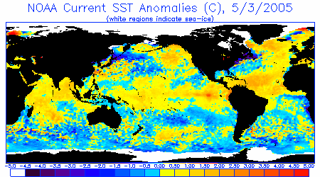
Sea Surface Temperature Anomalies
Courtesy: NOAA NESDIS
Notice a small thin but pronounced tongue of warmer than normal water (orange-red) extending west from Ecuador, created by a solid Kelvin Wave hitting the coast there. Also notice the oranges right along the coast. Also notice warmer than normal water extending from the dateline eastward to South America, a indicative of mild El Nino conditions. Otherwise warmer than normal water is well.cgiaced over the tropical Atlantic and in the Gulf of Alaska.
.
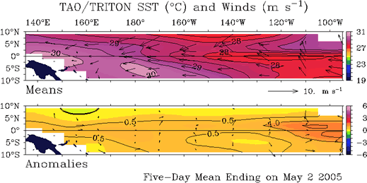
Sea Surface Temperature Anomalies and Average Surface Winds on the Equatorial Pacific
Courtesy: NOAA PMEL
In the top image notice average winds blowing from east to west, the standard trade wind pattern for this time of year. Notice in the lower image the anomalously warm pool of water off South America caused by the impacting Kelvin Wave and warmer than normal water extending over most of the tropical Pacific. This pools were generated by strong west to east blowing winds associated with the MJO in March. Wind above this water now is near neutral, or normal for this time of year.
.
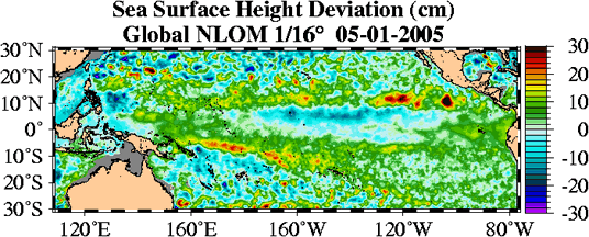
Sea Surface Height Deviation
Courtesy: NLOM
Contrasted to image above, notice that sea surface heights are slightly below normal right over the equator and over the same area where the seas are warmer. This is a bit unexpected.
.
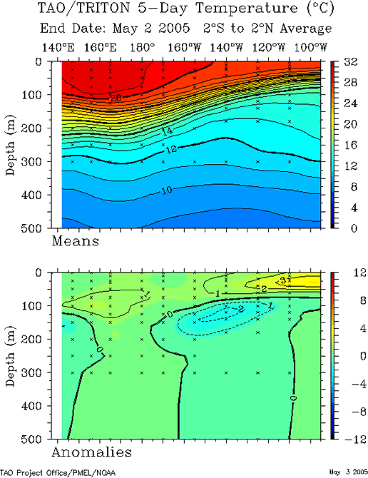
20 Degree Thermocline Depth and Position Time Series
Courtesy: CPC NCEP NOAA
(Top Image) A core of warm subsurface water is centered in the West Pacific but much of it has moved eastward since the last report, lessening the angle between the West and East. This is attributable to the Kelvin Wave hitting the Ecuadorian coast.
(Lower Image) Notice a pocket of anomalously warm water (3°+ C) at the far upper right hand corner of the image, located at the surface off Ecuador. This the Kelvin Wave produced 2 months ago by strong westerly winds in the West Pacific by a pulse of the MJO. Also notice another weak one at 1° C starting to develop near 160E at 100 meters down, from a milder Westerly Wind Burst in late April.
.
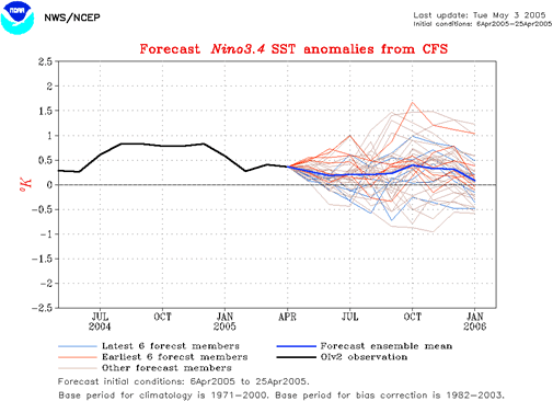
Equatorial Pacific Sea Surface Temperature Forecast
Courtesy: NOAA/NCEP
Notice that the average of many separate runs of the NCEP model suggest a continuation of a very mild to near normal warm temperature through the fall/winter of 2005/2006. This is consistent with most other available ENSO modeling tools/suites.
.
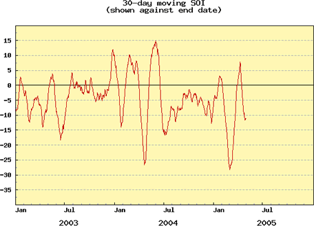
Southern Oscillation Index (SOI)
Courtesy: BOM
The SOI depicts the difference in pressure between Tahiti and Darwin Australia. When it is consistently negative, that is the pressure is lower in tahiti than Darwin, the trend is then towards El Nino. And when it is positive the trend is towards La Nina. Strong pulses of the MJO send the SOI negative for short periods of time (2-5 weeks). Notice the recent spikes downward in February 2005 and more recently in April. The MJO remains active. And the SOI on the whole has been negative for almost a year, typical of a weak El Nino.
|