Neutral Conditions In-Place
No Change Expected
The winter of 2003/2004 was characterized by a generally neutral trend with occasional strong signals of a developing El Nino. But that has now settled down to a neutral pattern as we prepare to exit the 'spring predictability barrier', moving into the start of the summer season. The months of March through June, a.k.a. the 'spring barrier', often provide false signals or no accurate indication of what's in-store for the coming months, making forecasting difficult. This year is no different.
Looking at current seasonally adjusted Sea Surface Temperatures (SST) across the equatorial Pacific, water temperatures are slightly warmer than normal across much of the region by 0.5 to 1.0° C, while a cool tongue of water to -2° C started developing off Columbia stretching west over the Galapagos Islands to about 120W. This is fairly typical of the time of year as easterly winds off Central America start pushing the warm surface waters of the East Pacific to the west and cooler water upwells along the coast then drifts west too, pushed by the stronger than normal surface winds. If this continues to evolve strongly (which it does not appear to be doing) one might start to speculate that La Nina was developing. Elsewhere in the Pacific warmer than normal waters are present along the US west coast (as they have been much of the winter). Also a broad pocket of slightly warm water is present in the mid-South Pacific from New Zealand east almost to the South American coast and southward to Antarctica. Also warm waters are present over nearly the entire North Pacific from Japan to the US west coast with only one small cool pool just off Kamchatka (Siberia). The high level view indicates most warmer waters are concentrated in the western half of the Pacific.
QuikSCAT imagery and wind anomaly analysis indicates nothing unusual one way or the other, with trades (east-to-west winds) extending across all the Equatorial Pacific, as-is normal, with a bit of higher winds over the cool tongue off Columbia at 15-20 kt and another patch west of Hawaii, but too far north to probably have any impact. Trend over the past few months indicate trades have been a little stronger than normal over the Eastern Pacific though, from South America to about 160W. If El nino were in.cgiay, one would expect to see slack to no trades. If La Nina was in-effect, the trades would be blowing much harder to the west. In all, winds look fairly normal for the time of year.
Another indicator of El Nino or La Nino is a change in sea surface height measurements. Seas surface height, that is, the height of the oceans surface relative to 'average' as indicated by satellite analysis depicts a thin band of waters running about 10 centimeters higher than normal spanning the whole width of the north half of the equator in the Pacific. This is above normal, but not unusually so. Interestingly, an even thinner band of normal to slightly lower than normal waters spans the entire width of the southern half of the Pacific equator with one pocket to -10 cm near 125W and a second just east of the Philippines. The data is inconclusive at this time.
The 30 and 90 day average Southern Oscillation Index (SOI) are mixed. This index compares barometric surface pressure between Darwin, Australia and Tahiti. A negative anomaly (signaling El Nino) indicates that lower than normal surface pressure is present over the Central Pacific while higher than normal pressure is in the West Pacific. A positive SOI (La Nina) means the pressure pattern is reversed. During April the 30 day trend was very negative, indicating El Nino, but has since returned to normal (starting May 9). The steep dip was associated with an increase in the Madden Julian Oscillation (MJO) over the West Pacific during that time-frame (more details below). The 90 day trend still shows a mildly negative trend, but much of this is a carryover from Aprils strong negative pulse. Looking further back over the first 5 months of this year the trend has swung back and forth from negative to positive, with a tendency more towards the positive than negative. Still, the 90 day trend is near normal, indicative of neither El Nino or La Nina.
Another key indicator in the evolution of either an El Nino or La Nina event is the depth and profile of the 20 degree thermocline. During La Nina events, warm subsurface water remains pooled up in the far West Pacific near the equator. Cold surface and subsurface waters dominate the East Pacific, resulting in a steep angle from east to west, going from shallow in the east to deep in the west. In El Nino events, as warm subsurface water (i.e. Kelvin waves) migrate towards the eastern Pacific, the angle flattens and becomes more consistent across the equatorial Pacific. Latest data indicates that the thermocline is not much different than what it was a year ago. If anything warm water has actually made more in-roads into the East Pacific than last year at this time. Some of this may be due to a small warm pool of water tracking east at a depth of 100 meters centered at 160W. But in all there is no indication that El Nino is imminent. It again looks pretty normal for this time of the year and compared to last year (which was 'normal').
There was no indication that Kelvin wave activity was present: A Kelvin wave is a pool of warm water that travels under the oceans surface at a depth of about 150-200 meters. It is generated by a burst of strong east blowing wind in the West Pacific. As the warm water gains eastward momentum, it sinks and travels well under the oceans surface, only to reappear at the surface when it impacts the South America Coast. This results in the sudden appearance of warmer waters at the coast of Peru. Occasional eruptions are normal. Large and sustained eruptions are the hallmark of El Nino events. The source of Kelvin Waves, a negative SOI and reversed trades is directly related to the strength and frequency of the Madden Julian Oscillation (MJO). This weather pattern is responsible for the periodic strengthening of the anomalous westerly winds in the West Pacific which drive production of subsurface Kelvin waves, and also drive the SOI negative. When the MJO enters an active phase, El Nino indicators strengthen, and as it fades, so does El Nino. At this time there is no evidence of any Kelvin waves or significant MJO activity in the Pacific.
At this time there is no indication of either El Nino or La Nina. Trade winds and sea surface heights are normal. Sea surface temperatures are slightly indicative of La Nina, but that has only been in.cgiace for about a month. There is no indication of significant Kelvin Wave activity (nor would one expect there to be this time of year). Of interest is the seasonal hurricane forecasts produced by Dr. William Gray and the team at the University of Colorado. Their April 2nd forecast suggests that mild La Nina conditions are expected in the Eastern Pacific through the summer based on trends at key locations in all oceans over the past 6 months. This has also contributed to their assessment that, like most years in the recent past, enhanced tropical storm activity is expected for the the Atlantic hurricane season (northern hemisphere summer). If this develops, that would add some credence to their supposition that a mild tendency towards La Nina was present.
Of 11 ENSO models run in April 2003, 3 indicate warm (El Nino-like) conditions by September 2004 while 8 indicate neutral conditions. Of those that indicate El Nino, all suggest only a minimal El Nino at best. None indicate La Nina. Given that we are currently reaching the end of the spring predictability barrier, and the over-all meteorological pattern is near neutral, it seems reasonable that neutral conditions will persist. All prediction services strongly suggest that a fair amount of uncertainty is present since we are still in the predictability barrier, when forecast skill is at it's lowest, and that a clearer picture of what trends might develop will emerge through July.
LONG-RANGE NORTH PACIFIC STORM AND SWELL GENERATION POTENTIAL FORECAST
Summer -Fall 2004 Swell Generation Potential (for California & Hawaii) = 5.0
There is little to no data supporting a significant emergence of El Nino, especially seeing how current indicators suggest just the opposite. Most likely we will continue in a neutral phase with no tendency toward either El Nino or La Nina. All predictive data continues to suggest we are in a neutral phase with no significant deviation expected in the coming few months. After that there is some suggestion that a mild El Nino might develop, but that is just a bit of idle speculation at this time. So for now,.cgian on a 'normal' summer with some occasional southern hemi swells (with a few already materializing, including a rather energetic Swell #2S on 4/27). But no large scale pattern worthy of notice is expected. Further out (towards the northern hemisphere Fall) the trend is less clear, but most data suggests a neutral pattern.
In short, expect a normal summer and fall from June to December 2004.
(This forecast is highly speculative and based on historical analysis of past La Nina/El Nino events and the latest long-range forecast models)
Sea Surface Temperature Anomalies
Courtesy: NOAA NESDIS
Notice a small thin tongue of cooler than normal water (dark blue) extending west from Ecuador, created by upwelling from easterly winds off the land there. Otherwise generally warm (yellow - but not too warm) conditions prevail over the rest of the tropical Pacific, though they seem a bit more concentrated in the West.
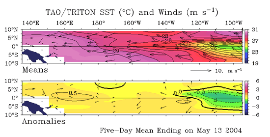
Sea Surface Temperature Anomalies and Average Surface Winds on the Equatorial Pacific
Courtesy: NOAA PMEL
In the top image notice winds actually blowing from east to west, strongest in the East Pacific, about normal for this time of year. Notice in the lower image which depicts deviations from normal that winds are blowing just a bit stronger to the west than would be normal, but not much and that water temperatures are a bit warmer in the West Pacific and definitely cooler right off Ecuador. The water temp pattern is being driven by the surface winds.
Sea Surface Height Deviation
Courtesy: NLOM
Like the images above, notice that sea surface heights are slightly below normal right over the equator but near normal to slightly above around the edges.
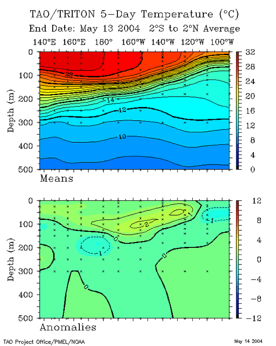
20 Degree Thermocline Depth and Position Time Series
Courtesy: CPC NCEP NOAA
(Top Image) A core of warm subsurface water is centered in the West Pacific with cooler waters in the East Pacific. This is actually a fairly normal configuration.
(Lower Image) Notice one pocket of anomalously warm water (2° C) at 150W and at about 100 meters deep. This is likely the transition point between the cooler waters to the east and warmer waters to the west, but could also be a a Kelvin Wave pushing east from anomalously strong westerly winds in April when the MJO was strong in the West Pacific.
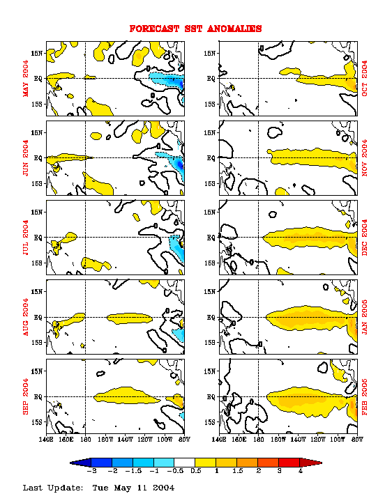
Equatorial Pacific Sea Surface Temperature Forecast
Courtesy: NOAA/NCEP
Notice that 4 separate runs of the NCEP model (started at 4 separate times) suggests a mild warming trend starting near July and increasing slowly through the end of the year. This is a minority opinion not shared by many other ENSO modeling tools/suites.
Equatorial Pacific Sea Surface Temp Forecast
Courtesy: NCEP/CMB
NCEP Model: Notice Sea Surface Temps are to remain basically neutral August 2004, but then a small pool of warm waters are to start building in the east, typical of a weak El Nino. This model is of a minority opinion though compared to 10 others.
|