Issued:
11/01/2002
Updated
as Warranted
See
ENSO page for Links and Current Data
ENSO Archives
MODERATE EL
NINO HAS DEVELOPED
Additional Strengthening
Possible
The first signs of El Nino appeared during March 2002 and have steadily increased in intensity through the year. At this time a moderate El Nino is in.cgiace and is expected to hold through the winter of 2002/2003. The Pacific weather pattern has been affected by the evolution of El Nino and will likely enhance the storm track through the winter months.
Our last update (August 2002) indicated seasonally adjusted Sea Surface Temperatures (SST) across the equatorial Pacific ranged from 0.5 to 1.5 degrees C above normal, with the core of the warmest waters positioned just east of the dateline at 170W. That pool of warmer waters has now increased it's temperature and coverage, extending the entire length of the equatorial Pacific from west of the dateline eastward to the coast of Ecuador with temperatures at least 1 degree Celsius above normal over the whole range, and a moderate sized core 2.5 degrees C above normal centered at 165W with a secondary core at 110W at 2 degrees C above normal. The imagery is fairly impressive and is stronger than anything that was forecast even a few months earlier. The occasional weaknesses in the warm pool off the South American coast that were evident midsummer have completely disappeared, and solid warmer-than-normal temperatures prevail. This is consistent with evolution of a moderate El Nino. Near normal temperatures prevail off the Philippines and the West Pacific, r.cgiacing cooler than normal conditions that had taken hold there during the summer. Cooler than normal temperatures are still present off the California coast, caused by upwhelling driven by an enhanced north wind pattern that continues to hold on, though less so lately. These north winds are being generated by a stubborn high pressure system that has been in.cgiace about 600 nmiles west of the Central CA coast all summer.
Trade winds along the equator in the West and Central Pacific remain near calm, typical of El Nino. QuikSCAT imagery and wind anomaly analysis indicates that trades remain supressed from the Philippines eastward to east of the dateline (165W). Winds have not exceeded 10 kts in quite some time and in September there were instances of dual low pressure centers straddling the equator driving strong winds from west to east (reversed from normal direction). These winds are responsible for driving much of the warm surface water that is currently working it's way east towards the South American coast. There remains evidence of stronger than normal westerly winds right over the core of the warmest waters (at 165W), but it's areal coverage is down from it's peak a month or so earlier.
Sea surface height, that is, the height of the oceans surface relative to 'average' is well above normal, providing more evidence that warmer water is present along the equator. (Water expands as it warms, causing sea heights in the area of the warmer waters to rise/increase.) A well defined band of ocean heights at least 14 cm above normal extends almost the entire way across the equatorial Pacific from 165E to 110W, with the the core of that area ranging from 20-25 cm above normal between the dateline to 135W. This is a significant increase in areal coverage and height from the last update. This data further confirms the temperature pattern indicated above and supports the assessment that El Nino has reached a moderate strength.
Looking at the larger scale picture, waters of the North and South Pacific are near normal in most all locations except over the equator and off California (as mentioned above). Some cooler than normal temperatures are present in the far North Pacific near the dateline, but are the result of upwhelling caused by a rather recent series of storms there, unrealted to El Nino. The Pacific warm water 'horseshoe' pattern that was so prevalent during the La Nina years has completely dissipated. The only curious pattern that remains is two areas of slightly cooler water that are streaming west off southwestern South America and Africa, appearing to be mirror images of each other. No e.cgianation available at this time.
The 30 and 90 day average Southern Oscillation Index (SOI) continues to remain negative as is has since March of 2002. This index compares barometric surface pressure between Darwin, Australia and Tahiti. A negative anomaly (signaling El Nino) indicates that lower than normal average pressure is present over the Central Pacific while higher than normal pressure is in the West Pacific. A positive SOI (La Nina) means the pressure pattern is reversed. Starting in March 2002, the SOI went mildly negative and continued building on that trend. From 7/14-10/22 the "daily SOI" average has been negative every single day but for 2 or 3 minor exceptions, with three short bursts of occasional very strong negativity (the latest in the first half of October). Of some concern is recent weakness in the SOI index starting October 23. It has gone neutral and the forecast models indicate is to remain that way for the foreseeable future. Perhaps this is the first signs that El Nino has peaked out, but it is too early to say with any certainty. If the SOI remains neutral well into November, one could begin to think that with more certainty though.
Another key indicator in the evolution of either an El Nino or La Nina event is the depth and profile of the 20 degree thermocline. During La Nina events, warm subsurface water remains pooled up in the far West Pacific near the equator. Cold surface and subsurface waters dominate the East Pacific, resulting in a steep angle from east to west, going from shallow in the east to deep in the west. In El Nino events, as warm subsurface water (i.e. Kelvin waves) migrate towards the eastern Pacific, the angle flattens and becomes more consistent across the equatorial Pacific. Our last report indicated the thermocline angle had actually steepened and lost some ground, attributable to a persistent thin band of trade winds trying to hold on off Ecuador and causing upwhelling off the South American coast. That has completely abated now and warm water is in total control not only at the surface but in the subsurface currents as well. Under the equator from the dateline to the South American coast a stream of warmer than normal water is present at a depth of about 150 meters. It is at least 3 degrees C above normal with a core at 5-6 degrees C above normal. This is consistent with an eastward moving Kelvin wave, generated by strong westerly winds at the surface in months previous. A Kelvin wave is a warm pocket of subsurface water that tracks east, driven by east winds in the West Pacific. There was a temporary breakdown in the Kelvin wave cycle in late June, but that breakdown has fully corrected itself. The strength and size of the latest Kelvin wave points towards a moderate El Nino.
The hallmark of this developing El Nino has been the on-again off-again strength of the Madden Jullian Oscillation (MJO). This weather pattern is responsible for the periodic strengthening of the anomalous westerly winds in the West Pacific which drive production of subsurface Kelvin waves, and also drive the SOI negative. When the MJO enters an active phase, El Nino indicators strengthen, and as it fades, so does El Nino. This El Nino has consistently had it peaks and valleys, unlike the El Nino of 97/98 which came on like a bull and didn't stop till it was out of steam. This years El Nino's indicators continue to have nowhere near the consistency and momentum of it's predecessor, making it more susceptible to momentary lapses in strength. We are currently in one such phase, where current MJO signals are very weak to nonexistent. MJO is known to falter during the summer months and is typically strongest during the change in seasons. Unfortunately, a Fall re-strengthening has not materialized, and that is being evidenced by several indicators including the neutral SOI and neutral trades in the West Pacific. This could signal that El Nino has reached it's peak.
It appears that degraded trade winds and the ensuing warmup of the sea surface water has been in.cgiace long enough and with enough intensity to not only modify the atmospheric pattern above it, but to start building some momentum to that pattern change, though we're looking for a more dramatic increase in storm activity in the North Pacific to confirm this suspicion. The Atlantic hurricane season, though not a bust, had virtually no tropical storms making significant headway through the Cape Verde storm corridor. Instead they developed in the Caribbean or formed relatively close to the US east coast and tracked northeast toward the Azores (with a few exceptions). The signals were not strong enough to conclude that El Nino's influence was particularly strong there, but not so weak as to indicate it had no influence either. The Atlantic storm season was definitely weaker than past years though.
Of 12 ENSO models run in October 2002, 7 indicate neutral conditions becoming dominant by March 2003. This is considered normal from a historical perspective in that the physical processes that cause El Nino to develop start breaking down in the late summer. This is consistent with what we are observing too in regards to the SOI and trades. Sea-surface temperature forecasts from NOAA/NCEP indicate mildly warm equatorial water conditions through February 2003, then retracting for several month to near neutral. Of far more interest is the fact that a slim majority of the models are now suggesting that this winters El Nino is not the end of the cycle, but perhaps just a start. Of nine predictions available, five suggest warm conditions are to start re-evolving in June and building into the fall months of 2003.
LONG-RANGE NORTH PACIFIC STORM AND SWELL GENERATION POTENTIAL FORECAST
Fall/Winter
2002 Swell Generation Potential (for California & Hawaii) = 5.0/7.5
(Scale
is from 1-10 with a 1 equaling low potential and a 10 equal to high potential)
There remains little time left in the window for potential redirection of late season typhoons off Japan towards the open waters south of the Aleutians and towards the Gulf of Alaska, enhancing the probability for extratropical storm development. But, the continued development of small and weak tropical systems this late in the season is interesting, suggesting the season change is running perhaps a month later than normal.
Confirmed and forecast data for the fall and winter of 2002 indicates that a moderate El Nino is in.cgiace. As is typical in El Nino events, they tend to a.cgiify the North Pacific jetstream, enhancing the strength and duration of storm systems there. This in-turn enhances the potential for swells to be generated from these storms. Some evidence is present to suggest this is the case now. A increase in the intensity and frequency of these storms (above normal levels) is expected in the winter months.
(This forecast is highly speculative and based on historical analysis of past La Nina/El Nino events and the latest long-range forecast models)
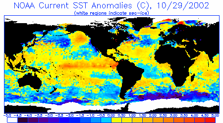
Sea Surface Temperature Anomalies
Courtesy: NOAA NESDIS
Notice a dark core of warmer than normal water that extends along the equator
from just east of New Guinea nearly straight eastward to South America. Warm
water also branches north along the Central American to Baja Mexico. Warm water
also covers much of the North Pacific extending eastward from Japan into the
Gulf of Alaska, with a cooler patch over the dateline associated with upwhelling
there from recent storms. Also notice the pair of cooler streams flowing west
off the western coasts of South America and Africa, and a cooler patch off California
associated with high pressure/north wind upwhelling there.
 |
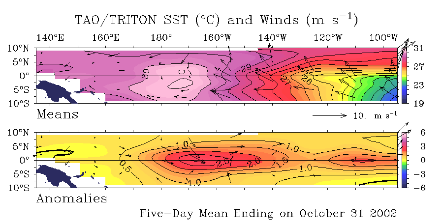
Sea Surface Temperature
Anomalies and Average Surface Winds on the Equatorial Pacific
Courtesy:
NOAA PMEL
Notice warmer than normal SST conditions currently (+1.0 degrees C) cover the
balance of the equatorial Pacific from 160E to the south America coast. A core
of warm water to 2.5+ C is imbedded at about 1650W. Also notice anomalously
neutral winds over the entire West Pacific to the core of the warm water area,
with some stronger westerly anomalies there. Calm winds prevail from the core
of the warm waters to South America.
 |
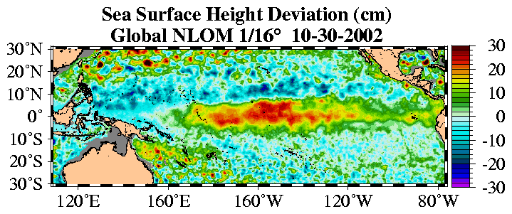
Sea Surface Height Deviation
Courtesy:
NLOM
Notice that seas heights are higher than normal almost continuously along the
equator from 160E to South America. This is much longer, wider and higher than
even 2 months ago.
 |
20 Degree Thermocline Depth
and Position Time Series
Courtesy:
CPC NCEP NOAA
(Top Image) A core of warm subsurface water that dominates the West Pacific
continues to make solid progress east, especially in the 100-130W range. This
is a significant improvement over images from 2 months ago. (Lower Image) Notice
the pocket of Anomalously warm water at 5 degrees above normal pushing eastward
(a Kelvin Wave) centered at 140W. Notice no alot of warm water is moving in
behind though. Also notice cool subsurface water in the far West Pacific
 |
Equatorial Pacific Sea Surface
Temperature Forecast
Courtesy:
NOAA/NCEP
Notice that 4 separate runs of the model (started at different times) indicate
water temperatures over the Central Pacific are to remain above normal through
the winter of 2002/2003 and for the foreseeable future. Also notice that the
observed temperatures are actually higher than what the models are projecting,
indicating that they are not resolving some of the real-time elements of this
El Nino.
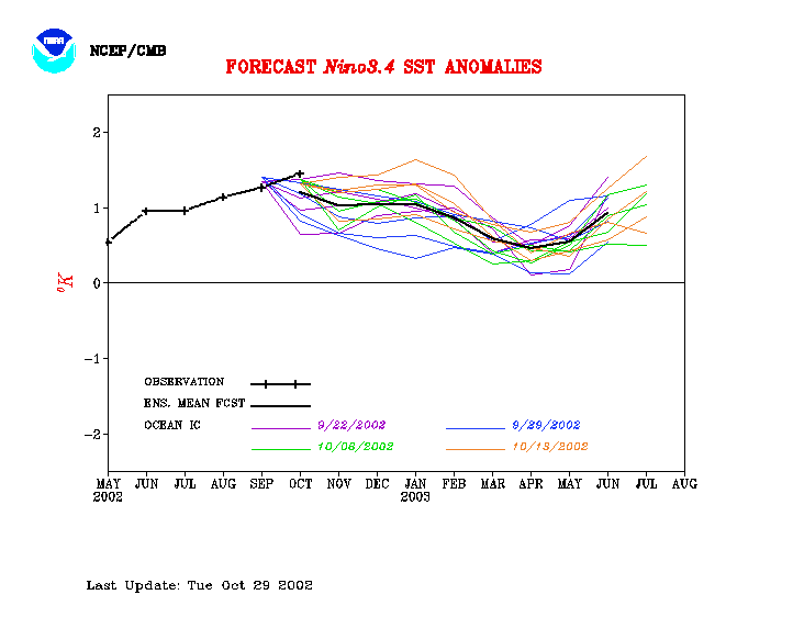 |
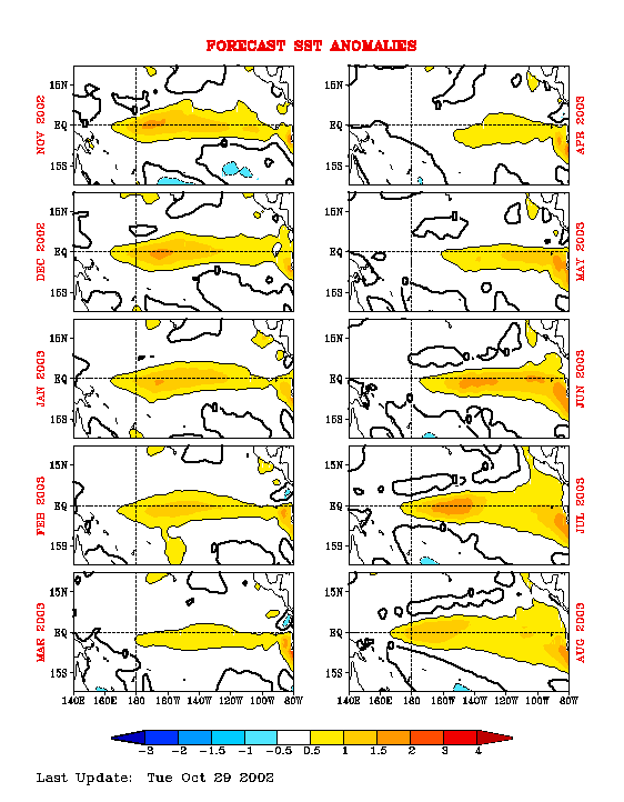
Equatorial Pacific Sea Surface Temp
Forecast
Courtesy: NCEP/CMB
NCEP Model: Notice Sea Surface Temps are to remain above normal through February
2003, then cool off some (though still slightly above normal). Of real interest
is the renewed strengthening of warm temperatures in June 2003.
 |
9056
|
||||||||
|
||||||||
