El Nino Tries to Stir
But Neutral Conditions Prevail
We'd first like to take a minute to apologize for the amount of time since the last ENSO update. We are hot in the middle of a major software development effort that has limited our ability to maintain some of the other components of this site. We believe that the new functionality these upgrades will provided will be more than worth the short-term inconvenience they may create. Thanks for your understanding.
After a long summer of near neutral conditions with occasional hints of La Nina occasionally showing, a consistent pattern of neutrality with tendencies towards El Nino has started to emerge. This pattern is expected to remain unchanged through the winter, with a possible El Nino developing by late Spring.
Seasonally adjusted Sea Surface Temperatures (SST) across the equatorial Pacific have provided the strongest sign of a potentially emerging El Nino. These water temperature have been consistently running at normal with pockets up to 1.0 degree C above normal, with the core of warmest waters positioned over the dateline and another stronger one over the Galapagos Islands. This is in stark contrast to this summers off-and-on pattern of cooler than normal waters off South America. During these episodes surface waters often dipped 1.0-1.5 degree C below normal, though confined mostly to the eastern equatorial Pacific. This pattern was actually quite normal, and even a bit on the restrained side, especially considering this was the first summer after a moderate El Nino winter (2002-2003). During such years, it is not un-common to see a full scale La Nina develop. Instead, we're seeing neutral conditions with a tendency towards El Nino. Somewhat unusual. Regardless, these warmer waters across the equatorial Pacific owe their existence to a relaxed flow of the normal trade winds across the area. Winds are anomalously neutral to blowing even slightly east, helping to push warmer water which normally resides in the West Pacific to the East. There is certainly no upwelling occurring along the South American coast either. Elsewhere in the Pacific normal to slightly warmer than normal waters are present along the US west coast, the South American west coast and spread uniformly 30 degrees north and south of the equator across the entire Pacific. Conversely, cooler than normal waters are present in the far South Pacific (start about 50 degrees S) and the far North Pacific from Kamchatka the whole way east to the Gulf of Alaska.
QuikSCAT imagery and wind anomaly analysis indicates a complete absence of trade winds along the equator in the West Pacific to the dateline, with some small pockets of east moving winds. From 160W to South America winds were light from the east, but not more than 10 kts. This is probably as much as we'll see since this a the peak of the season for slack trades. During El Nino events, a similar wind pattern would be expected, though more pronounced.
Another indicator of El Nino is a change in pattern is sea surface height measurements. Seas surface height, that is, the height of the oceans surface relative to 'average' as indicated by satellite analysis depicts a thin band of waters running about 10 centimeters higher than normal spanning the whole width of the equator in the Pacific with a maximum pocket to 16 cms above normal located near 160W. This is above normal, but not unusually so. What is interesting is the length and consistency of the band though. There were no pockets of below normal height over the entire distance. Higher than normal water heights typically represent the presence of warmer than normal waters, and lower than normal heights represent cooler than normal water. So this imagery supports the previous mentioned data suggesting warmer than normal waters over the equatorial Pacific.
The 30 and 90 day average Southern Oscillation Index (SOI) are near neutral though. This index compares barometric surface pressure between Darwin, Australia and Tahiti. A negative anomaly (signaling El Nino) indicates that lower than normal surface pressure is present over the Central Pacific while higher than normal pressure is in the West Pacific. A positive SOI (La Nina) means the pressure pattern is reversed. On a daily and weekly basis, the trend has had little variability with only occasional swings far from the norm. And these swings are evenly distributed and rather far apart, indicative of a fairly stable pattern. This is likely an indication that though surface winds over the equator are near neutral to slightly in favor of El Nino, there is not much support at a large scale atmospheric level to push this pattern into a full scale El Nino. If anything, the SOI could be used as a leading indicator to see whether additional ocean warming is likely, which it surely does not indicate.
Another key indicator in the evolution of either an El Nino or La Nina event is the depth and profile of the 20 degree thermocline. During La Nina events, warm subsurface water remains pooled up in the far West Pacific near the equator. Cold surface and subsurface waters dominate the East Pacific, resulting in a steep angle from east to west, going from shallow in the east to deep in the west. In El Nino events, as warm subsurface water (i.e. Kelvin waves) migrate towards the eastern Pacific, the angle flattens and becomes more consistent across the equatorial Pacific. Latest data indicates that after the 2002/2003 El Nino, the bulk of the warm subsurface waters retreated to the west as would be expected. But a complete transition to a La Nina like configuration did not occur, as was originally thought earlier this year. Instead, the core of the warm subsurface waters retreated west, but a series of weak to moderate Kelvin waves have occurred, driving warmer subsurface waters towards the South American coast. The warm water currently pooling up off South America is a result of these Kelvin waves. (Note: A Kelvin wave is a pool of warm water that travels under the oceans surface at a depth of about 150-200 meters. It is generated by a burst of strong east blowing wind in the West Pacific. As the warm water gains eastward momentum, it sinks and travels well under the oceans surface, only to reappear at the surface when it impacts the South America Coast. This results in the sudden appearance of warmer waters at the coast of Peru. Occasional eruptions are normal. Large and sustained eruptions are the hallmark of El Nino events.) The corridor these waves travel underwater remains open with no large scale cold blocking features present, but the volume of warm water present is quite small. Compared to last years Kelvin wave activity, this year is weak, though certainly not nonexistent as would be expected during a La Nina year.
The source of Kelvin Waves, a negative SOI and reversed trades is directly related to the strength and frequency of the Madden Julian Oscillation (MJO). This weather pattern is responsible for the periodic strengthening of the anomalous westerly winds in the West Pacific which drive production of subsurface Kelvin waves, and also drive the SOI negative. When the MJO enters an active phase, El Nino indicators strengthen, and as it fades, so does El Nino. At this time there is no evidence of any Kelvin waves or significant MJO activity in the Pacific.
At this time trade winds and sea surface heights are slightly indicative of El Nino. But the SOI index is about as neutral as it can get, and there is no indication of significant MJO or Kelvin Wave activity. The upper level weather pattern in the North Pacific also is not showing any bias towards El Nino, with the storm pattern in the Gulf of Alaska certainly being rather benign so far this season. Normally El Nino would enhance the fall storm track and often increases the number of extratropical storms migrating from Japan into the East Pacific. It also has a tendency to increase the number of tropical systems in the Eastern tropical Pacific, none of which has been evident this year. Also the Atlantic hurricane pattern this year was solid, with several strong storms threatening the US East coast. The Atlantic hurricane corridor was wide open for an extended period of time as is typical of neutral to mild La Nina years. One last signal to watch for would be the evolution of enhanced rain and storm activity on the equator near the dateline. This feature, if it develops, is often associated with the MJO and the Hawaiian Pineapple Express rain pattern, historically responsible for bringing large quantities of rain from Hawaii over California. At this time there is little to no evidence of this developing, but if El Nino like conditions continue to hold in place, the development of above average cloudiness over the dateline would be a early sign.
Of 11 ENSO models run in October 2003, virtually all indicate neutral conditions continuing through March of 2004. This seems reasonable too especially in light of the neutral SOI, MJO and Kelvin wave levels and is consistent with what we are observing in regards to pacific weather patterns. Four models suggest a return of El Nino by June of 2004.
But, the March to June period is known as the "predictability barrier (Spring Barrier) " and model skill is at its lowest during this time frame. Sea-surface temperature forecasts from NOAA/NCEP indicate the same, with neutral equatorial water conditions through April 2004, then a warming trend developing in June and expanding through August 2004.
LONG-RANGE NORTH PACIFIC STORM AND SWELL GENERATION POTENTIAL FORECAST
Fall 2003/Winter 2004 Swell Generation Potential (for California & Hawaii) = 4.5
There is little to no data supporting a sudden resurgence of El Nino, especially seeing how we're in the peak of the season right now. Most likely we will continue in a neutral phase with a slight bias towards El Nino, but no overt signs of it actually materializing. NOAA/CPC is actually suggesting that we are in a borderline El Nino state, but our analysis indicate it is not strong enough to have significant upper level atmospheric influence to add much fuel to the North Pacific storm track. And if anything, the pattern so far this year (summer and fall) has been rather subdued. It is possible for a bit more energetic storm track to develop in the later winter and early spring if current El Nino like conditions prevail for the next few months. But it's still a bit too early to expect that with any level of certainty. So for now, plan on a rather static and subdued fall and early winter storm pattern resulting in less frequent and smaller swells. This is not to say periodic larger storm and swell events won't occur, but they will not be the norm. We'll continue to watch to the late winter for a possible slight resurgence, but are not particularly hopeful at this time.
In short, expect slightly less than normal winter swell activity from November to January 2004, with a slight upward shift perhaps in February.
(This forecast is highly speculative and based on historical analysis of past La Nina/El Nino events and the latest long-range forecast models)
Sea Surface Temperature Anomalies
Courtesy: NOAA NESDIS
Notice a broad area area of warmer than normal surface water temperatures (yellow/light orange) that extend from Central America westward the whole way to the Philippines and beyond. Also notice the core of dark orange directly off Columbia and the Galapagos Islands and a much lighter area in the mid-Pacific. But also notice the cooler than normal waters (dark blue) in the Gulf of Alaska and the deep southern hemisphere.
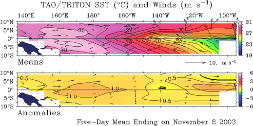
Sea Surface Temperature Anomalies and Average Surface Winds on the Equatorial Pacific
Courtesy: NOAA PMEL
In the top image notice winds actually blowing from west to east in the far West Pacific, contrary to the way normal trade winds would blow. In the bottom image (anomalies) notice the same wind pattern but more pronounced and warmer than normal water under these winds. Also neutral (normal) winds prevail over the Eastern Pacific with the warmer than normal water pool depicted off Columbia.
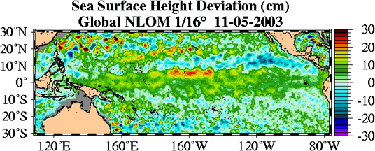
Sea Surface Height Deviation
Courtesy: NLOM
Like the images above, notice that sea surface heights are slightly above normal in the same region as the warmer than normal waters, further confirming the warm waters presence.
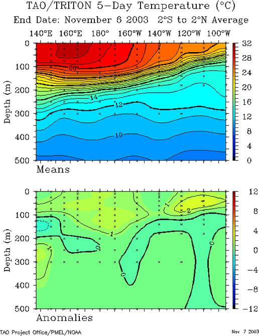
20 Degree Thermocline Depth and Position Time Series
Courtesy: CPC NCEP NOAA
(Top Image) A core of warm subsurface water that dominated the Central Pacific last year at this time has returned to a more normal position, back to the West Pacific, typical of neutral conditions.
(Lower Image) Notice one pocket of anomalously warm water (2 degrees C) at 120W and at about 50 meters deep, likely a Kelvin Wave starting to impact the South America coast and causing the warmer than normal waters there. In the West Pacific another slightly warmer subsurface pool exists (1 degree C), but not concentrated. This one is worth monitoring though.
 |
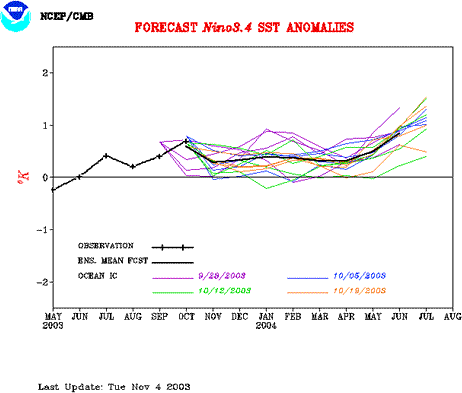
Equatorial Pacific Sea Surface Temperature Forecast
Courtesy: NOAA/NCEP
Notice that 4 separate runs of the model (started at different times) indicate water temperatures over the Central Pacific are to remain at or slightly above normal through the winter of 2004. But the margin of warmness (less than .5 degrees) is small enough to be considered neutral. It's better than being negative.
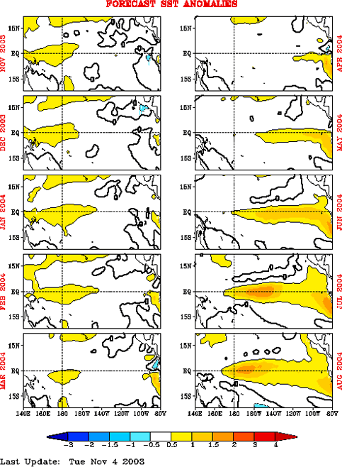
Equatorial Pacific Sea Surface Temp Forecast
Courtesy: NCEP/CMB
NCEP Model: Notice Sea Surface Temps are to remain basically neutral through April 2004, but then warm waters are to start building in the east, typical of a moderate El Nino.
|